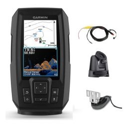
A marine GPS chartplotter is the centre of a boat’s navigation system. It shows your position on a detailed chart in real time, plots routes, stores waypoints and warns you about shallow water and hazards. Many chartplotters also combine with sonar so that you can fish and navigate on the same screen. With so many sizes, chart options and feature lists on offer, buyers often feel unsure what they actually need. This guide explains how a chartplotter works, which features matter, how to match one to your boat and how to budget for the whole installation rather than just the display.

What a marine GPS chartplotter does
A chartplotter combines a GPS receiver with a digital chart display. The GPS tells it where you are, and the chart shows what surrounds you: depth contours, channels, buoys, hazards and landmarks.
Real-time position
Your boat appears as an icon on the chart, with a heading line showing where you are going. The picture updates as you move, so you can see approaching hazards before you reach them.
Routes and waypoints
You can plan a route from your launch to a destination, with turns along the way. Waypoints mark favourite fishing spots, hazards and landmarks. Our guide to marine GPS waypoints shows how to use them well.
Tracks and history
A chartplotter records where you have been. A track helps you retrace your path in poor visibility and review a day on the water afterwards.
Chartplotter versus fish finder combo
Many anglers choose a combined unit.
Chartplotter only
A pure chartplotter focuses on navigation with a larger screen and better chart handling. It suits cruising, offshore and sailing.
Fish finder and chartplotter combo
A combo adds sonar to the chart screen, which is ideal for fishing boats. Read our guide to fish finder chartplotter combos for how to choose.
Standalone and networked options
Larger boats often run a dedicated chartplotter alongside a separate fish finder, connected by a network. This offers flexibility and redundancy.
Screen size and display quality
The display is where you will notice differences every day.
Choosing a size
A small screen is fine for a kayak or small boat, while larger screens suit consoles where you want to show chart and sonar side by side. Think about viewing distance and available space.
Brightness and sun readability
The best screen is one you can read in full sun. Look for good brightness, an anti-glare coating and wide viewing angles.
Touch, keys or both
Touch is convenient for panning charts, and keys are easier in rough water. Many units offer both.
Charts and mapping
Charts determine how useful the chartplotter is where you boat.
Built-in base maps
Most units include a basic map. It is enough for general orientation but may lack the detail needed for tight channels and fishing contours.
Detailed charts
Detailed charts add depth contours, navigation aids and more. Check which charts are available for your region and whether they are included or sold separately.
Updates
Charts change as channels shift and aids move. Make sure you can update your charts easily. Our guide to how to read nautical charts helps you interpret what you see.
GPS performance and accuracy
GPS accuracy matters for both navigation and fishing.
Update rate
A faster update rate gives smoother movement on the screen and more precise tracks, which helps when trolling or running tight channels.
Antenna position
Built-in antennas need a clear view of the sky. Some units support an external antenna for better reception on boats with cabins or canopies.

Sonar options
If your chartplotter includes sonar, think about the type.
2D and CHIRP
Read our CHIRP fish finder guide to see why CHIRP matters.
Imaging
Down imaging and side imaging add picture-like views. Our comparison of side imaging vs down imaging explains which to choose.
Transducer compatibility
Confirm which transducer is included and how it connects.
Networking and expansion
A chartplotter can grow with your boat.
Connecting multiple screens
Networking lets you share charts and sonar between displays, useful on larger boats.
Adding other devices
Radar, autopilot, VHF and engine data can connect to some systems. Only buy networking features that you will genuinely use.
Power, mounting and installation
Installation shapes performance.
Power supply
Use a clean, fused supply with adequate battery capacity. See our boat wiring basics.
Mounting options
Choose between a bracket, a flush mount or a pod. Our mount guide shows the differences.
Waterproofing and durability
Marine units are built to resist spray. Still, protect connectors and keep them dry.
Choosing a chartplotter for your boat
Match the unit to your use.
Small boats and kayaks
Compact units with built-in GPS suit these craft. See our marine electronics for small boats guide.
Fishing boats
Choose a combo with sonar and charts, and think about imaging if you fish structure.
Cruisers and larger boats
Bigger screens and networking help with longer trips. Our boat navigation safety basics gives more advice.
Common buying mistakes
- Buying the largest screen without checking space on the console.
- Forgetting to budget for charts, mounts and wiring.
- Assuming all chartplotters accept all transducers.
- Overlooking sun readability.
- Buying features you will not use.
Getting the most from a new chartplotter
The first few outings with a chartplotter are the best time to build good habits. Before leaving the dock, check the date, time and units, and confirm that the chart region matches the water you are on. Set the boat icon to show a heading line, and choose a chart orientation you find easy to read, such as north up or course up. Drop a waypoint at the launch so you can always return to the ramp. As you gain confidence, create a few routes to places you visit often and save them with clear names.
Run a practice day on familiar water
Familiar water is the best classroom. Compare what the chart shows with what you can see, and notice how your speed and heading appear on screen. You will quickly learn how the unit handles zoom, how fast the track draws and how to find the menu you use most.
Keep software and charts up to date
Fresh software fixes bugs and improves performance, and up-to-date charts show recent changes in channels and markers. Make a habit of checking before each season so surprises do not appear on the water.
Chartplotter use cases: lake, river and coast
Where you boat shapes what you ask of a chartplotter, so think about your typical day before you decide on features.
Large lakes and reservoirs
On big inland water a chartplotter helps you navigate between distant fishing areas and avoid submerged hazards such as old roadbeds or shallow humps. Detailed lake charts with depth contours show you where structure lies before you ever look at sonar, which makes planning a day far more efficient. A reasonably large screen helps when you want a chart and a sonar view at the same time.
Rivers and tidal water
Rivers change with every flood and tides move channels, so up-to-date charts and a careful lookout matter. A chartplotter gives you a safety margin in low light and in unfamiliar stretches, but never rely on it alone in moving water. Use it alongside your own observation and local knowledge.
Coastal and offshore trips
Coastal boating adds distance, weather and navigation rules, so charts with detailed navigation aids become important. Routes and alarms such as shallow-water and off-course warnings add safety. Read our offshore fishing electronics guide and boating in fog tips for more on staying safe when conditions change.
How much should you spend?
It is tempting to buy the biggest screen you can afford, but a better approach is to decide which features actually change how you use the boat. A modest screen with the right charts and a clean installation outperforms a premium unit that is poorly mounted or powered badly. Start by listing your must-have features, then compare units that meet them and set aside part of your budget for the transducer, mounts, cables and charts. Our marine electronics budget guide shows one way to split a budget sensibly across these parts.
Frequently asked questions
What is the difference between a GPS and a chartplotter?
A GPS provides position, while a chartplotter displays that position on a detailed chart and includes planning tools.
Do I need a chartplotter on a small lake?
Not always. A fish finder with GPS may be enough for small waters.
Can a chartplotter replace paper charts?
It can be primary navigation, but keep a backup such as a paper chart or compass. See our marine compass backup guide.
Are charts included with the unit?
Some basic maps are, and detailed charts may cost extra. Check the product page.
Choosing with confidence
The right marine GPS chartplotter fits your boat, shows charts you trust and does the jobs you need without extra complexity. Start with your water and your style of boating, choose a screen you can read, and budget for the whole installation. Browse GPS and chartplotter options in our shop, or contact us for personal advice.
Related reading from Fishtrail Outfitters
- Best Fish Finder for Beginners: How to Choose Your First Sonar
- Boat Navigation Safety Basics: Using GPS, Charts and Common Sense
- Handheld Marine GPS vs Chartplotter: Which Do You Need on the Water?
- Marine Compass Backup Navigation: What to Carry When Electronics Fail
- How to Read Nautical Charts: Depths, Symbols and Hazards Explained
Products mentioned in this guide
- Fishfinder Furuno FCV 600
- Fishfinder Furuno FCV 800
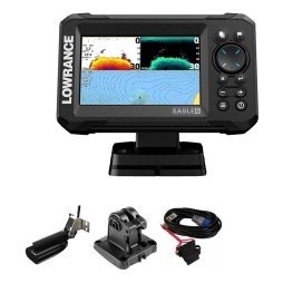
- Lowrance Eagle 5 CHIRP Splitshot Gps Fishfinder + 455/800 KHz Transducer
Further reading: U.S. Coast Guard Navigation Center · Take Me Fishing: how to get started and where to fish
Questions before you buy? Contact Fishtrail Outfitters or browse the shop.